How AI & space imagery are used in aid work
This post was originally written for the Frontier Development Lab program of Trillium Technologies. Learn more about the Frontier Development Lab.
Helping the helpers: Shining light on informal settlements with satellite imagery and AI
A team of researchers from FDL Europe in partnership with UNICEF has developed first-of-their-kind tools and resources for mapping the world’s informal settlements. These tools and resources are now freely available online and can even be used on laptops by communities and aid workers in the field.
People living in informal settlements are many of the world’s poorest people. They lack access to essential infrastructure such as electricity and clean water, often while being exposed to dangerous environmental conditions. Addressing the needs of people living in informal settlements is critical to achieving several of the United Nations sustainable development goals, but gathering the necessary information to serve these vulnerable communities has historically been difficult.
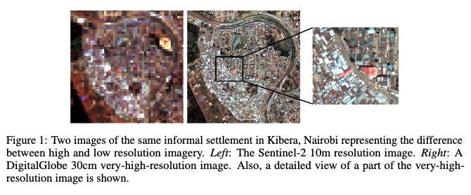
Previous efforts to study informal settlements with machine learning and satellite imagery focused only on specific regions or relied on very-high resolution (VHR) imagery (down to 30cm per pixel) which can be expensive not only to access but also to work with. Through active partnership with UNICEF, the FDL team devised a method for using freely available, but lower resolution multi-spectral imagery (ranging 100cm or 200cm per pixel) from the Sentinel-2 mission. With this, the team developed a cost-effective and more user-friendly method for detecting and mapping informal settlements around the world by spectral signatures.
This cost-effective approach leverages Canonical Correlation Forests (CCFs) which, in addition to being computationally efficient, are data efficient meaning that they are a strategic choice for the sparse ground truth datasets that exist for informal settlement research. In addition to the cost-effective CCF approach, the FDL Europe research team also developed a more computationally intensive Convolutional Neural Network method to work with VHR imagery that can detect contextual features. This is sometimes necessary for distinguishing between formal and informal settlements where spectral data is not sufficient to differentiate due to identical building materials or other factors.
One of the prevailing challenges of developing informal settlement mapping techniques with satellite imagery is the scarcity and inaccessibility of ground truth data which can sometimes be locked away in PDF or even less accessible formats. To accompany the two mapping methods that the FDL Europe research team has produced, the team has also composed a series of annotated ground truth datasets and published the first ever benchmarks for detecting informal settlements.
All of these methods, datasets, benchmarks, and further information can be found for free on the Frontier Development Lab website.